How forest conservation is helping Saudi Arabia achieve its green objectives

main

NADA HAMEED-17 May 2024

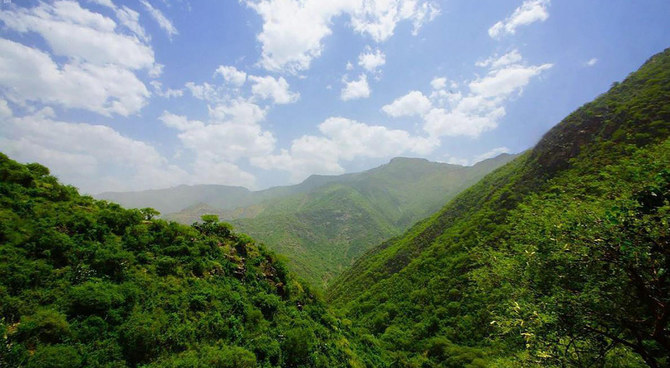
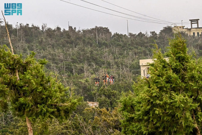
A view of “Tahlal” mountains in Rijal Almaa governorate, in the southwestern province of Asir. (SPA)

Short Url

https://arab.news/9wcfr

  • By planting trees and protecting forests, the Kingdom promotes biodiversity and sustainable development
  • Forests provide habitats for hundreds of animal species and play a pivotal role in combating climate change 

JEDDAH: With its low annual rainfall, much of Saudi Arabia’s vast landscape is covered by desert, broken by occasional oases. In its mountainous regions, valleys, and along its coastline, however, the Kingdom is home to multiple forest ecosystems.

Forests play a pivotal role in combating climate change by acting as carbon sinks — storing carbon both above and below ground, thereby extracting it from the atmosphere, where it would otherwise contribute to the greenhouse effect.

Their significance in climate change adaptation and mitigation is also underscored by their role in creating local microclimates, providing habitats for a wealth of biodiversity, locking in freshwater resources, and preventing flash floods, landslides, and soil degradation.


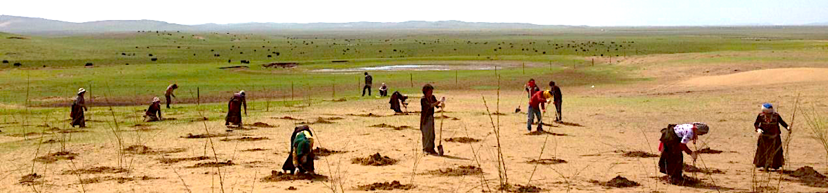
Riyadh residents take part in a tree-planting project as part of the Greener Home initiative. (@Riyadh_Green/File)

Saudi Arabia’s National Center for Vegetation Cover Development and Combating Desertification is at the forefront of implementing the Kingdom’s strategic goals outlined in Vision 2030.

“Forests play a crucial role in mitigating climate change,” Samir Malaika, assistant director-general of the general administration of forests at NCVC told Arab News. “Saudi Arabia’s dry climate and geography hinder its efforts to conserve forests and promote plant growth.

“With most areas receiving minimal rainfall, forests struggle to thrive. The escalating impact of climate change exacerbates environmental stressors, hampering forest growth and regeneration efforts.”

The NCVC aims to elevate living standards by reducing pollution and facilitating the restoration of degraded environments. It is also committed to building resilience against natural hazards and defenses against harmful pests that could pose risks to vegetation.

Simultaneously, it prioritizes the sustainable development of the Kingdom’s natural resources. With seven ongoing initiatives, it aims to ensure the responsible and lasting utilization of resources in line with the nation’s sustainability objectives.

Among the center’s key initiatives under the Saudi Green Initiative is a scheme to plant some 10 billion trees — representing a significant step in the Kingdom’s reforestation effort.

The initiative for forest management and sustainable development by 2030 underscores a long-term commitment to nurturing and preserving woodland environments.

The phased approach to preserving and restoring vegetation in pasture areas reflects a strategic focus on addressing the specific ecological challenges faced by different ecosystems.

Furthermore, the initiative for developing vegetation and infrastructure for 50 national parks highlights the importance of creating protected natural spaces while promoting biodiversity and ecotourism.

Moreover, the initiative to plant 7 million wild trees in royal reserves demonstrates a targeted effort to enhance the natural habitats within these pristine areas.

Engagement by the public and private sectors in vegetation development and combating desertification underscores the collaborative approach needed in order to achieve sustainable environmental goals.


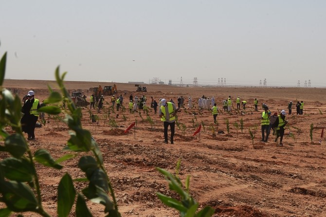
One initiative of the National Center for Vegetation Cover Development and Combating Desertification with the aim of achieving sustainable forest management is to tap local community participation in agroforestry projects and by promotingecotourism. (Photo Courtesy: NCVC)

By harnessing the collective resources and expertise of various stakeholders, these initiatives aim to create a resilient and thriving ecosystem that benefits both present and future generations.

According to Malaika, Saudi Arabia boasts a forest coverage spanning approximately 2,768,050 hectares, primarily concentrated in the southern and southwestern regions, along riverbeds, and on the coastlines of the Red Sea and the Arabian Gulf.

These forest ecosystems are categorized into three primary types: mountain, valley, and mangrove.

Mountain forests

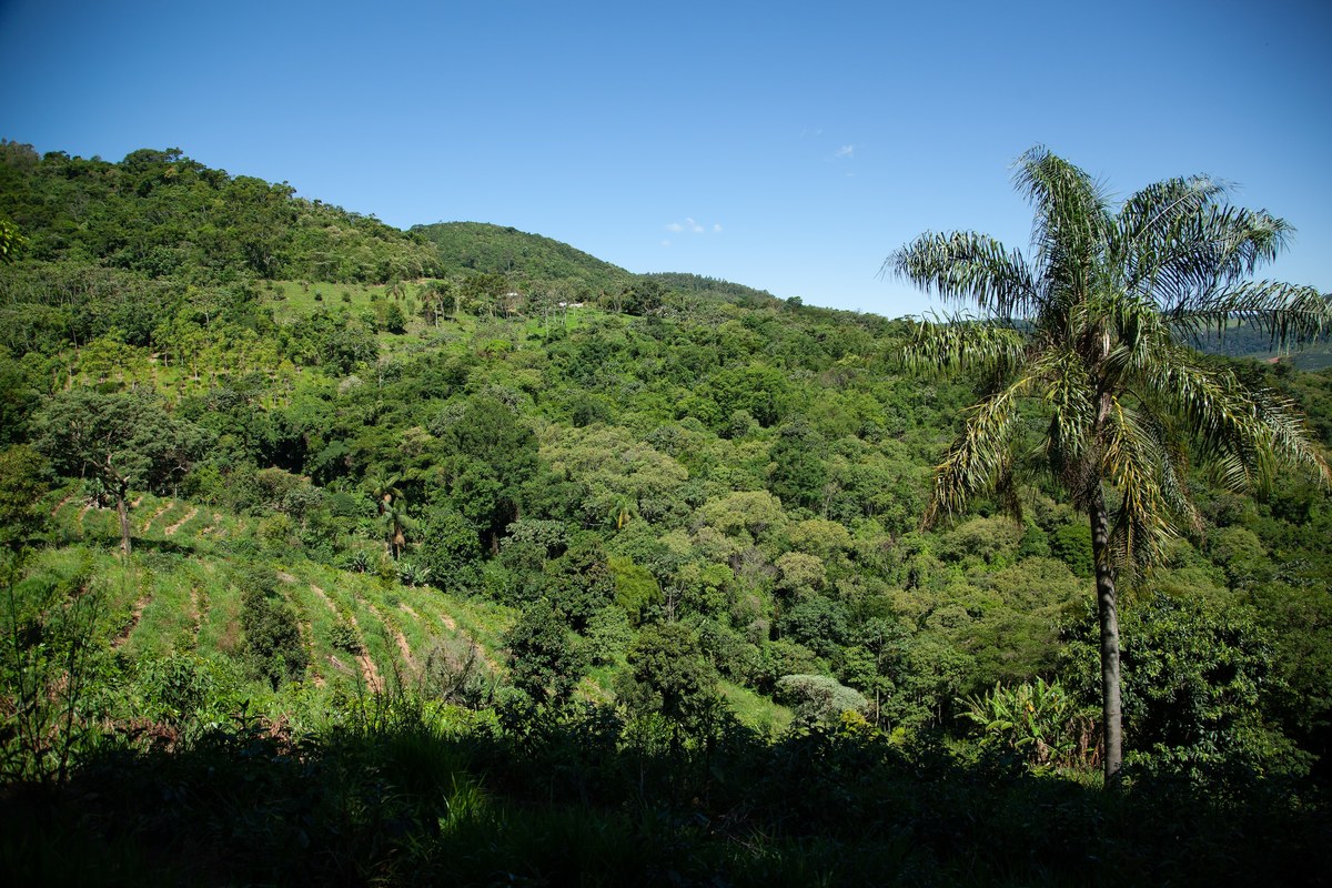
Mountain forests are predominantly located in the region spanning the Hijaz Mountains in Taif to Jazan in the south. These areas have neutral soil acidity and receive the highest rainfall and humidity levels, particularly evident in the southwest with denser forest cover.


The juniper tree has proudly stood as a symbol of picturesque beauty in Al-Baha region, adorning its slopes and mountain peaks with vibrant green hues. (SPA)

Forests are made up of several Juniperus plant species, typically found at altitudes of 2,000 meters and above. Additionally, Olea chrysophylla forests, characterized by wild olive trees with golden leaves, thrive at altitudes of 1,500 to 2,000 meters.

At lower altitudes, between 1,000 to 1,500 meters, Acacia plant species dominate the landscape.

Notably, terraced agriculture is a common feature of mountainous regions, facilitating crop fruit tree cultivation while aiding in water retention and soil protection. However, improper management can lead to land degradation, adversely affecting the surrounding forests.
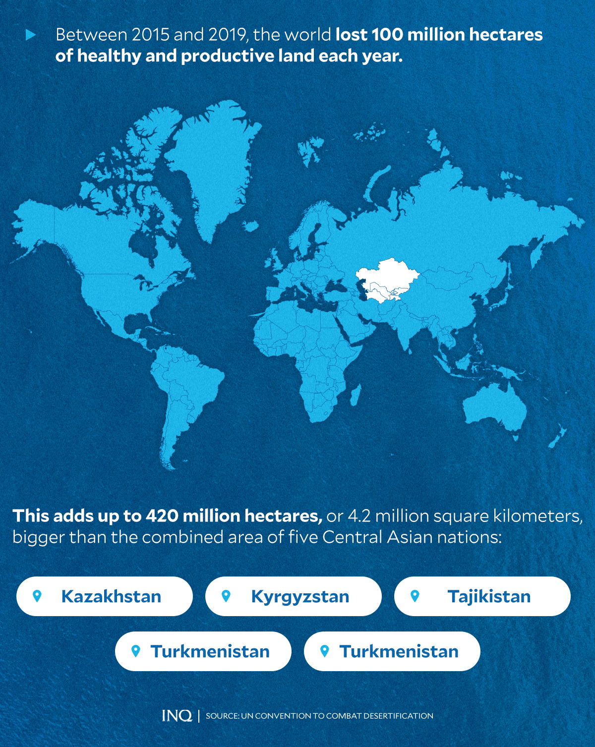
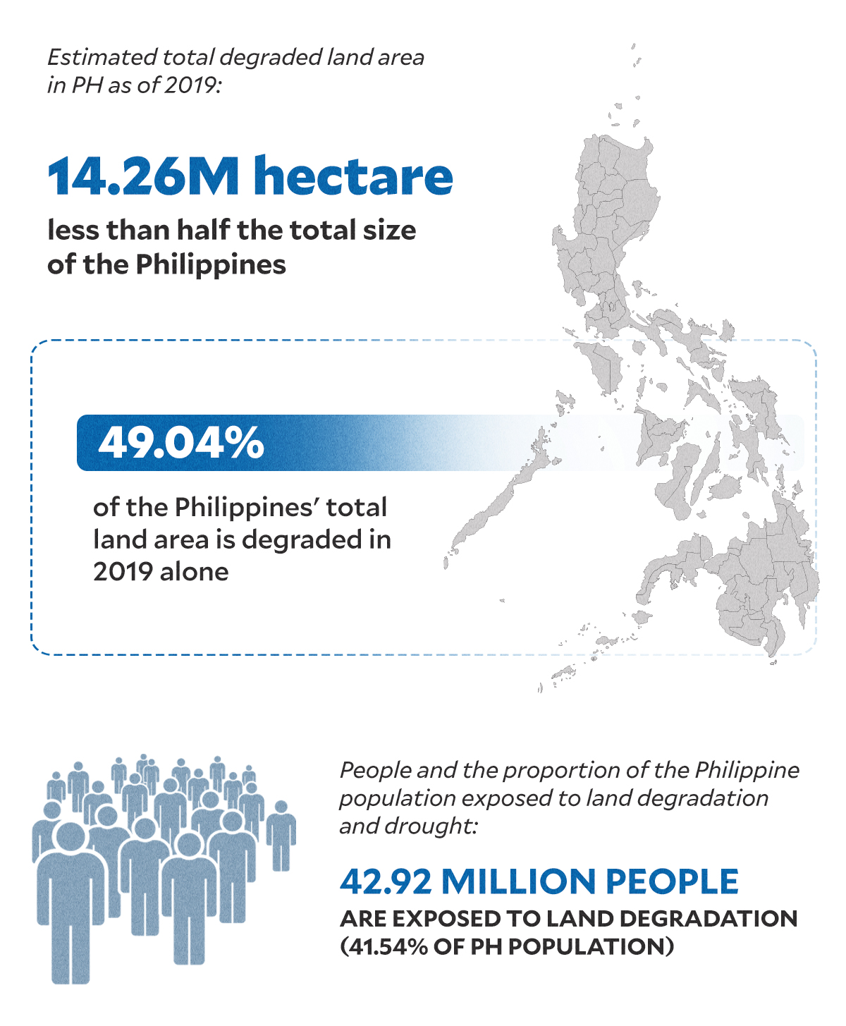
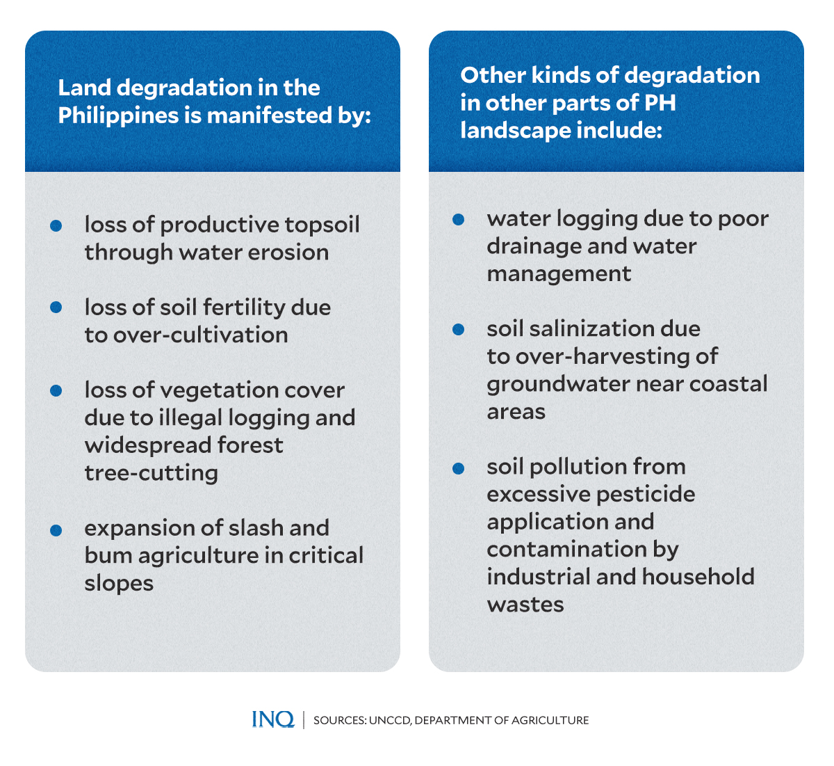
Buckle Up For More Dust Storms Thanks To Land Degradation, Climate Change

The extraordinary dust and thunderstorms have come just when concerns have been mounting about the rapid rate of desertification in several Indian states

Shailendra Yashwant

The sand and dust storm (SDS) that shrouded Mumbai for two hours, and ended up killing 16 and injuring over 40 people on May 13 was not an unexpected or freak event. Earlier on May 11, at least two people were killed and 23 injured in storm-related incidents as strong winds uprooted trees, electricity poles and led to portions of walls collapsing across Delhi. Last week Manipur bore the brunt of a sand and dust storm that left several injured.

In India dust storm and thunderstorm activity usually peak in the pre-monsoon period, between March and May. During this period, temperatures can go up to 45 degrees Celsius, which can lead to these kinds of storms. Fluctuations in intensity, magnitude or duration can make them unpredictable and dangerous. The worst sand and dust storms India experienced was on May 2, 2018 when severe dust storms, thunderstorms and lightning hit several parts of India, resulting in the deaths of at least 124 people and injuries to 300 others. Two weeks later on May 13, fierce dust and thunderstorms led to the deaths of at least 40 more people, while several others were injured.

Sand and dust storms (SDS) are defined as storms caused by intense winds over areas of arid soil that pick up large amounts of ground material in the atmosphere. SDS are not new phenomena — they are a regionally common and seasonal natural phenomenon exacerbated by poor land and water management, droughts and climate change. However, there is growing alarm over the increasing frequency and intensity of sand and dust storms and their negative repercussions on the economic, social and environmental dimensions of sustainable development in the Asia Pacific region.

Sand and dust storms are a global phenomenon, stretching from the Sahara Desert and the Middle East to the Great Indian Desert and the mid-latitude deserts of Central Asia, China and Mongolia. Dry-land areas cover over 40% of the Earth’s land surface and include some of the most fragile ecosystems, highly susceptible to the impacts of climate change. A sizeable portion of the impacted area lies in the Asia-Pacific region.

A combination of climate change and land mismanagement is stripping semi-arid areas of vegetation, leading to desertification and feeding a series of more frequent, more brutal storms. Human activities, like deforestation, over grazing and the overuse of water, are causing deserts to spread and increasing the likelihood of sand and dust storms. Climate change — which is bringing droughts and more extreme temperatures — is amplifying these factors.

Approximately two billion tonnes of sand and dust enters the atmosphere each year, according to the UN coalition to combat desertification. The Asia-Pacific region is the second-largest in terms of dust emissions, contributing more than half a billion tonnes per year. These particles can travel for hundreds and occasionally thousands of miles when carried by wind. In some areas, desert dust has doubled in the 20th century, increasing the chance of sand and dust storms.

SDS events do not usually result in extensive or catastrophic physical damage. However, the accumulation of impacts can be significant. In source areas, they damage crops, kill livestock, and strip topsoil. Atmospheric dust, especially in combination with local industrial pollution, can cause or worsen human health problems such as respiratory diseases. The impacts of SDS on agriculture further threatens food security in populations already struggling with severe desertification and drought. The rising concerns led the UN General Assembly to proclaim July 12, 2023 the first-ever International Day of Combatting Sand and Dust Storms.

Combating sand and dust storms requires accelerated action and relevant capacity in multiple- hazard risk reduction for both adaptation and mitigation. But first there is urgent need to overcome the gaps in information and knowledge by connecting science, policy and actions. According to the World Meteorological Organization addressing sand and dust storms requires an integrated approach, which involves sustainable land management, climate change mitigation and adaptation, disaster risk reduction including early warning systems and international cooperation.

The extraordinary dust and thunderstorms have come just when concerns have been mounting about the rapid rate of desertification in several Indian states. According to the Desertification and Land Degradation Atlas of India, published by the Indian Space Research Organisation, 97.84 million hectares of land in India was degraded in 2018-19. Increasing desertification would mean more intense and damaging dust storms in the future.

However, the phenomenon of SDS is difficult to control directly: drought or deforestation in one part of the world can lead to sand storms in another. But we can control the conditions that lead to land drying up and dust gathering in the air by large-scale ecological restoration of degraded land.

Africa has already taken the lead with its Great Green Wall for the Sahara and the Sahel Initiative (GGWSSI), first launched in 2007, that aims to restore 100 million hectares of land by 2030 from Senegal on the west coast to Djibouti in the east, helping to reverse desertification and improve food security for the people of the area. Once complete, it will be the largest living structure on the planet, three times the size of the Great Barrier Reef.

China’s Ningxia achieves major progress in ecological protection

Source: Xinhua-Editor: huaxia

Provincial officials of northwest China’s Ningxia Hui Autonomous Region attend a press conference in Beijing, capital of China, May 20, 2024. (Xinhua/Jin Liangkuai)

BEIJING, May 20 (Xinhua) — Northwest China’s Ningxia Hui Autonomous Region has prioritized ecological protection in its pursuit of high-quality development, achieving advancements in water conservation and desertification control, among other areas, according to a press conference held in Beijing on Monday.

Ningxia is located in arid and semi-arid regions, with its per capita water resources significantly lower than the national average.

“Water resources have always been valued as a core element in Ningxia’s development,” said Zhang Yupu, chairman of the autonomous region, noting that Ningxia has intensified efforts to promote water conservation.

Official data showed that by the end of 2023, all prefecture-level cities in Ningxia achieved the national standards for water-saving cities. Moreover, the goals concerning water consumption per 10,000 yuan (about 1,408 U.S. dollars) of gross domestic product (GDP) and per 10,000 yuan of value-added industrial output for the 14th Five-Year Plan (2021-2025) period have been achieved ahead of schedule.

Ningxia has also made remarkable progress in preventing and controlling desertification. The treatment of 8.2 million mu (546,667 hectares) of desertified areas, originally planned for completion by 2030, is now expected to be finished three years ahead of schedule, Zhang said.

Ningxia’s GDP expanded 5.8 percent year on year in the first quarter of 2024, with the growth rate remaining among the top 10 in the country for eight consecutive quarters, according to the press conference. ■

Desert restored via grassland protection

Horqin left banner turns desolation to green by embracing natural methods

By Yan Dongjie | China Daily | 

Workers carry straw used to control sand in Horqin Left Wing Rear Banner, Inner Mongolia autonomous region. LIAN ZHEN/XINHUA

On grassland in Horqin Left Wing Rear Banner, clusters of white flowers bloom on the Chinese hawthorn. In this area, where grazing is prohibited, trees, shrubs and grass coexist, presenting a green landscape in the spring.

Horqin Left Wing Rear Banner is located in the southeastern part of Horqin Sandy Land in the Inner Mongolia autonomous region. Due to ecological imbalances, the land here had a desertification rate as high as 80 percent decades ago, making it one of the most severely desertified areas in the country with an extremely fragile ecology.

“The Chinese hawthorn is a typical native tree species, and its growth plays a crucial role in improving the local ecosystem. We have been researching the optimal tree density for the best natural ecological restoration,” said Wang Feng, a professor and the director of the Policy and Strategic Development for Combating Desertification, Chinese Academy of Forestry.

He emphasized that the goal is not to completely eradicate every grain of sand but to stabilize and balance the sand by having grass, trees and shrubs present.

Wang explained that this grassland is a sparse tree grassland, a naturally formed landscape. The terrain of the sand dunes is uneven, making engineering methods challenging, so natural restoration methods are more suitable.

“In this area, with Chinese hawthorn, maple, elm trees and some shrubs in between, a symbiotic ecosystem of trees, shrubs and grass has formed. Without overgrazing and large-scale cultivation, based on the natural conditions here, this natural landscape can be maintained. Once this state is achieved, the sand will no longer shift, and the sand dunes will no longer pose a threat,” he said.

Chen Hui, Party secretary and director of the Forestry and Grassland Bureau of Horqin Left Wing Rear Banner, mentioned that to advance the governance of the sandy land, the local government has implemented comprehensive grazing bans in certain areas.

“Depending on local conditions, the autonomous region and banner government provide subsidies to herdsmen, which can be used to purchase feed to raise cattle and sheep. As long as the farmers’ income is ensured, everyone will naturally cooperate to protect the forests and grasslands, helping to achieve a faster restoration of the natural landscape,” he explained.

In addition to grazing bans, in recent years Horqin Left Wing Rear Banner has been planting trees.

“In Horqin Sandy Land, where evaporation rates are high and wind speeds are significant, the local area has developed the ‘deep planting and shallow burial’ afforestation technique based on these environmental characteristics,” said Chaoke Tu, director of Horqin Left Wing Rear Banner Forestry Station.

“Deep planting and shallow burial” is a new planting technique, involving planting seedlings in deep pits and covering them with a shallow layer of soil.

He mentioned that over the past decade, using this method to plant Mongolian Scot pine trees has increased survival rates to over 90 percent from about 50 percent. The seedlings grow vigorously, saving around 15,000 yuan per hectare in costs and reducing watering frequency by half, saving more than half the water resources.

Horqin Sandy Land is China’s largest sandy area and one of the three main battlefields of the “Three-North” Shelterbelt Project of China, covering parts of Inner Mongolia, as well as Liaoning and Jilin provinces. In Inner Mongolia alone, the total area exceeds 5.7 million hectares and involves Tongliao and Chifeng cities, as well as Hinggan League.

The “Three-North” project covers 13 provinces and regions in the north of China and the Xinjiang Production and Construction Corps, with a total area exceeding 42 percent of the country’s land area. Begun in 1978, the project is expected to last until 2050.

In Horqin Sandy Land, people employ methods such as using grass to stabilize the sand, aerial seeding for afforestation, road-based sand control and photovoltaic sand control to advance the governance of the sandy land.

By 2030, the autonomous region plans to achieve a desertification control rate of over 85 percent in Horqin Sandy Land.

S. China’s Guangxi addresses rocky desertification, brings prosperity to locals

People’s Daily Online)

South China’s Guangxi Zhuang Autonomous Region has treated rocky desertification on 515,300 hectares since it implemented a comprehensive program to control rocky desertification starting in 2008.

Since 2021, the autonomous region has harnessed 108,600 hectares of rocky desertification land, with the vegetation coverage rate of rocky-desertification land reaching 45.8 percent.

Li Rongguang, a 67-year-old villager, has planted trees for 35 years in Nonglatun, which was once haunted by rocky desertification, in the Guling neighborhood of Guling township, Mashan county, Nanning city.

“As long as I am still standing, I will keep planting trees,” Li said.

Since the 1960s, Nonglatun has been restoring the ecology through afforestation.

Over the decades, generations of villagers have planted over 16,000 bamboos, cypresses, and camphor trees. The forest coverage rate increased from 32.1 percent in 1980 to 97.5 percent in 2023, and has brought over 210 hectares of rocky-desertification land back to life.

Nonglatun’s changes reflect Guangxi’s achievements in combating rocky desertification.

According to a national survey on rocky desertification in 2021, the rocky desertification land area in the autonomous region dropped by 31.5 percent, or 14.5 percent of the total reduction nationwide, said Cai Zhongping, director of the forestry bureau of Guangxi. Guangxi ranked first in reducing areas of “severely” and “extremely severely” rocky desertification, and the ecological quality of vegetation in these areas.

Technology has given an advantage to Guangxi’s efforts to tackle rocky desertification. The Huanjiang observation and research station for karst ecosystems under the Chinese Academy of Sciences is located in Tongjin village, Dacai township, Huanjiang Maonan Autonomous County of Hechi city.

Since 1994, researchers have studied the ecosystems in karst areas in the county, and have provided scientific support for rocky desertification control.

Through long-term experiments, the observation and research station has selected 32 plant species, established a high-quality germplasm resource repository of 20 mu (1.33 hectares) and a 12,000-mu demonstration area which combined the ecological and economic benefits with mixed forests, grasslands, and medicinal plants.

Over the years, Guangxi has conducted scientific experiments on rocky desertification control technologies, selected and cultivated local tree species suitable for rocky-desertification areas, promoted practical techniques, and explored more than 10 treatment models. These have created a virtuous cycle of sustainable development.

The efforts to control rocky desertification have also driven income growth for local people through the planting industry and eco-tourism.

Yangshuo county in Guilin city has promoted the planting of a type of locust tree to tackle rocky desertification.

Qin Guipeng, deputy head of the villagers’ committee of Tangjia village in the county, who once worked outside his hometown, returned to grow orah mandarins, a thick-skinned citrus fruit, and locust trees.

“Last year, the price of locust tree flowers reached 50 yuan ($6.91) per kilogram, which was pretty high,” said Qin.

In recent years, Guangxi has advanced rocky desertification prevention and control through measures such as establishing protected areas and cultivating featured crops. Notably, several “rocky desert parks” in the autonomous region have attracted throngs of visitors.

Dying lands: Desertification taking another form in PH

By: Cristina Eloisa Baclig – Content Researcher Writer / @inquirerdotnet

INQUIRER.net /

MANILA, Philippines—Amid the various environmental challenges facing the Philippines, widespread land degradation poses a significant threat that could undermine the country’s agricultural productivity and food security.

Land degradation, as defined by the United Nations Convention to Combat Desertification (UNCCD), refers to the deterioration of land quality caused by human activities or natural phenomena.

This results in decreased productivity and usefulness of the land, which may involve vegetation loss, soil erosion, and depletion of soil fertility.

It has been noted that this environmental crisis could jeopardize the livelihood of millions and pose significant risks to the country’s ecosystems and overall health.

A global crisis

The UNCCD reported that globally, land degradation affects up to 40 percent of the planet’s land, directly impacting half of humanity and threatening half of the global gross domestic product (GDP), approximately $44 trillion.

READ: Dying lands: Farmers fight to save the ‘skin of the Earth

The latest UN data showed that between 2015 and 2019, at least 100 million hectares of healthy and productive land were degraded every year. This is equivalent to 4.2 million square kilometers, which is slightly over the combined area of five Central Asian nations: Kazakhstan, Kyrgyzstan, Tajikistan, Turkmenistan, and Uzbekistan.

The yearly environmental decline caused by massive land degradation significantly affected global food and water security, directly impacting the lives of 1.3 billion people.

Graphic by ED LUSTAN / INQUIRER.net

If current trends continue, the UN agency warned that an additional area almost the size of South America will be degraded by 2050.

Ibrahim Thiaw, executive secretary of the UNCCD, emphasized the urgent need for large-scale land restoration, calling it a powerful, cost-effective tool to combat desertification, soil erosion, and loss of agricultural production.

“Investing in large-scale land restoration is a powerful, cost-effective tool to combat desertification, soil erosion, and loss of agricultural production. As a finite resource and our most valuable natural asset, we cannot afford to continue taking land for granted,” Thiaw stated.

The UNCCD further stressed that around 1.5 billion hectares of land globally — roughly 150 times the size of the Philippines — must be restored by 2030 to achieve a land-degradation-neutral world.

Alarming PH situation

In the Philippines, the extent of land degradation is alarming.

As of 2019, an estimated 14.26 million hectares of land is degraded, representing 49.04 percent of the country’s total land area. This is equivalent to the entire regions of Ilocos, Cagayan Valley, and Central Luzon combined.

According to the UNCCD and the Department of Agriculture (DA), this degradation affects nearly 42.92 million people, which is about 41.54 percent of the country’s population, exposing them to the adverse effects of land degradation and drought.

Among the primary drivers of land degradation in the Philippines are illegal logging, unsustainable agricultural practices, and conversion of forests into agricultural land.

The Department of Environment and Natural Resources (DENR) has found that 75 percent of the country’s total cropland is vulnerable to erosion of varying degrees, leading to an annual loss of at least 457 million tons of soil for agriculture.

Graphic by ED LUSTAN / INQUIRER.net

The DENR noted that the conversion of lands for settlements and the annual loss of approximately 47,000 hectares of forest significantly contribute to soil degradation.

It added that 11 to 13 million hectares of land across the country are classified as degraded, while 2.2 million hectares face low soil fertility due to improper fertilizer and pesticide use, leading to soil pollution and increased acidity, exacerbating the problem.

The Bureau of Soils and Water Management of the DA explained that the manifestations of land degradation in the Philippines include:

  • Loss of productive topsoil through water erosion.
  • Loss of soil fertility due to over-cultivation.
  • Loss of vegetation cover due to illegal logging and widespread tree-cutting.
  • Expansion of slash-and-burn agriculture on critical slopes.

Other forms of degradation impacting the Philippine landscape encompass water logging due to poor drainage, soil salinization from over-harvesting of groundwater near coastal areas, and soil pollution from excessive pesticide application and contamination by industrial and household wastes.

How does it affect us?

The effects of land degradation extend beyond the immediate loss of arable land. It reduces food production, depletes water sources, and forces populations to migrate to more hospitable areas.

The World Health Organization (WHO) stressed that among the potential impacts of land degradation and desertification on health include:

  • higher threats of malnutrition from reduced food and water supplies
  • more water- and food-borne diseases that result from poor hygiene and a lack of clean water
  • respiratory diseases caused by atmospheric dust from wind erosion and other air pollutants
  • the spread of infectious diseases as populations migrate

WHO added that as land is degraded and deserts expand in some places, food production declines, water sources dry up, and populations are pressured to relocate.

Desertification and heat

A specific type of land degradation, known as desertification, has been impacting various countries globally and is feared to affect the Philippines.

Desertification, according to UNCCD, is a specific type of land degradation that occurs in arid, semi-arid, and dry sub-humid areas, resulting from various factors, including climatic variations and human activities.

It transforms fertile land into desert-like conditions, significantly affecting ecosystems and human livelihoods.

Graphic by ED LUSTAN / INQUIRER.net

Recent unprecedented high temperatures, with some areas experiencing extreme heat above 40 degrees Celsius in the first few months of 2024, have raised concerns. These conditions, studies showed, exacerbate the drying of soil and further aggravate degradation, impacting both agriculture and water resources critically.

Earlier this month, DA spokesperson Arnel De Mesa revealed that agricultural damage caused by El Niño has already reached P6.3 billion. The drought had affected 113,585 farmers and fishers in 12 of the country’s 17 regions, with the volume of production losses amounting to 255,467 metric tons in 104,402 hectares (ha) of agricultural land.

READ: El Niño damage to PH agri nears P6B

According to a 2023 study, the Philippines does not experience desertification in the typical dry land context. However, the country faces severe land degradation that compromises soil health and agricultural output.

Government promises

Last year, President Ferdinand “Bongbong” Marcos Jr. vowed to take significant action to protect and rehabilitate the country’s threatened soils. He emphasized the need for modern agricultural practices and robust soil conservation measures.

Marcos then also served as the agriculture secretary.

“[O]ur soil is under threat, and to continue to neglect this vital agricultural component will lead to an even worse crisis in the future,” Marcos warned.

The President proposed a five-point agenda on soil and water management, which includes the National Soil Health Program and the implementation of sustainable land management.

Graphic by ED LUSTAN / INQUIRER.net

“This will ensure the proper use and management of soil resources, address land degradation, enhance crop productivity, and, hence, improve farmers’ income,” he said.

READ: Bongbong Marcos on agriculture: ‘Our soil is under threat’

Marcos also said his administration is also investigating water security measures by implementing climate-resilient rainwater technologies and conducting cloud seeding operations.

He added that these initiatives aim to enhance water availability in agricultural production areas, critical watersheds, and reservoirs to mitigate the effects of the El Niño phenomenon.

UNCCD PRESS RELEASE


‘Silent Demise’ of Vast Rangelands Threatens Climate, Food, Wellbeing of Billions : UNCCD
Rangelands cover 54% of all land; as much as 50% are degraded,  imperilling 1/6th of humanity’s food supply, 1/3rd of Earth’s carbon reservoir UNCCD report points way to restore, better manage rangelands,  urges protection of pastoralism  Bonn/Ulaanbaatar 21 May 2024– Degradation of Earth’s extensive, often immense natural pastures and other rangelands due to overuse, misuse, climate change and biodiversity loss poses a severe threat to humanity’s food supply and the wellbeing or survival of billions of people, the UN warns in a stark report today. 
Authors of the Global Land Outlook Thematic Report on Rangelands and Pastoralists, launched in Ulaanbaatar, Mongolia by the UN Convention to Combat Desertification (UNCCD), say up to 50% of rangelands are degraded. Symptoms of the problem include diminished soil fertility and nutrients, erosion, salinization, alkalinization, and soil compaction inhibiting plant growth, all of which contribute to drought, precipitation fluctuations, and biodiversity loss both above and below the ground. The problem is driven largely by converting pastures to cropland and other land use changes due to population growth and urban expansion, rapidly rising food, fibre and fuel demands, excessive grazing, abandonment (end of maintenance by pastoralists), and policies that incentivise overexploitation. 

What are rangelands? 
.The rangelands category of Earth’s land cover consists mostly of the natural grasslands used by livestock and wild animals to graze and forage.  They also include savannas, shrublands, wetlands, tundra and deserts.   Added together, these lands constitute 54% of all land cover, account for one sixth of global food production and represent nearly one third of the planet’s carbon reservoir. “When we cut down a forest, when we see a 100-year-old tree fall, it rightly evokes an emotional response in many of us. The conversion of ancient rangelands, on the other hand, happens in ‘silence’ and generates little public reaction,” says UNCCD Executive Secretary Ibrahim Thiaw.  “Sadly, these expansive landscapes and the pastoralists and livestock breeders who depend on them, are usually under-appreciated,” Mr. Thiaw adds. “Despite numbering an estimated half a billion individuals worldwide, pastoralist communities are frequently overlooked, lack a voice in policy-making that directly affects their livelihoods, marginalised, and even often seen as outsiders in their own lands.” Mongolia Environment Minister H.E. Bat-Erdene Bat-Ulzii says: “As custodian of the largest grasslands in Eurasia, Mongolia has always been cautious in transforming rangelands. Mongolian traditions are built on the appreciation of resource limits, which defined mobility as a strategy, established shared responsibilities over the land, and set limits in consumption. We hope this report helps focus attention on rangelands and their many enormous values – cultural, environmental, and economic –  which cannot be overstated. If these rangelands cannot support these massive numbers of people, what alternatives can they turn to?” Mongolia will host the 17th UNCCD Conference of the Parties meeting in 2026, the International Year of Rangelands and Pastoralists (IYRP), declared by the United Nations General Assembly on Mongolia’s initiative. 

Two billion people – small-scale herders, ranchers and farmers, often poor and marginalised – depend on healthy rangelands worldwide.  

Indeed, in many West African states, livestock production employs 80% of the population. In Central Asia and Mongolia, 60% of the land area is used as grazing rangelands, with livestock herding supporting nearly one third of the region’s population. Ironically, the report underlines, efforts to increase food security and productivity by converting rangelands to crop production in mostly arid regions have resulted in degraded land and lower agricultural yields. The report calls out “weak and ineffective governance,” “poorly implemented policies and regulations,” and “the lack of investment in rangeland communities and sustainable production models” for undermining rangelands. 

An innovative approach 

The new report’s 60+ expert contributors from over 40 countries agree that past estimates of degraded rangeland worldwide – roughly 25% – “significantly underestimates the actual loss of rangeland health and productivity” and could be as much as 50%.  Rangelands are often poorly understood and a lack of reliable data undermines the sustainable management of their immense value in food provisioning and climate regulation, the report warns. The report details an innovative conceptual approach that would enable policy-makers to stabilise, restore and manage rangelands.   The new approach is backed by experience detailed in case studies from nearly every world region, drawing important lessons from successes and missteps of rangeland management. A core recommendation: protect pastoralism, a mobile way of life dating back millennia centred on the pasture-based production of sheep, goats, cattle, horses, camels, yaks, llamas or other domesticated herbivores, along with semi-domesticated species such as bison and reindeer.   Says Mr. Thiaw: “From the tropics to the Arctic, pastoralism is a desirable default – and often the most sustainable – option for that should be incorporated into rangeland use planning.” 

The economic engine of many countries  

Rangelands are an important economic engine in many countries and define cultures. Home to one quarter of the world’s languages, they also host numerous World Heritage Sites and have shaped the value systems, customs and identities of pastoralists for thousands of years.  The report includes detailed analyses of individual countries and regions. For example, livestock production accounts for 19% of Ethiopia’s GDP, and 4% of India’s. In Brazil – which produces 16% of the world’s beef – fully one-third of agribusiness GDP is generated by cattle livestock.  In Europe, many rangelands have given way to urbanisation, afforestation and renewable energy production.  In the United States, large tracts of grassland have been converted to crops, while some Canadian grasslands have been made fragile by large-scale mining and infrastructure projects.  There are also many positive notes such as, for example, growing efforts in both countries to reintroduce bison – an animal of great cultural importance to indigenous peoples – to promote rangeland health and food security.   

World areas most acutely affected by rangelands degradation,  ranked in descending order: Central Asia, China, Mongolia 

The replacement of government management and oversight with privatisation and agricultural industrialization left herders abandoned and dependent on insufficient natural resources causing widespread degradation. The gradual restoration of traditional and community-based pastoralism is leading to critical advances in sustainable rangeland management. 

North Africa and Near East 

The impact of climate change in one of the world’s driest regions is pushing pastoralists into poverty and degrading the rangelands on which they rely. Updated traditional institutions, such as Agdals – reservoirs of fodder used to feed animals in periods of critical need and allowing for the regeneration of natural resources – and incipient supportive policies are improving the way rangelands are managed. 

Sahel and West Africa 

Conflict, power balance and border issues have interrupted livestock mobility leading to rangelands degradation. Unified policies, recognition of pastoralists’ rights and cross-border agreements are reestablishing mobility for animal herders, crucial for landscape restoration.  

South America 

Climatic change, deforestation linked to industrialised agriculture and extractive activities, and land use conversion are South America’s main drivers of rangeland degradation. Multifunctionality and diversity of pastoralist systems hold the key for restoring some of the most interesting rangelands in the world, including the Pampa, the Cerrado and Caatinga savannahs, and the Puno Andean systems. 

East Africa 

Migration and forced displacement caused by competing uses of land (such as hunting, tourism, etc), are evicting pastoralists from their traditional lands, causing unanticipated degradation consequences. Women-led initiatives and improved land rights are securing pastoralists’ livelihoods, protecting biodiversity, and safeguarding the ecosystem services provided by rangelands.  

North America 

The degradation of ancient grasslands and dry rangelands threatens the biodiversity of iconic North American ecosystems such as the tall-grass prairies or the southern deserts. The incorporation of indigenous people to rangeland governance is a clear step to help recover these historic landscapes. 

Europe 

Policies favouring industrial farming over pastoralism and misguided incentives are causing rangelands and other open ecosystems to be abandoned and degraded. Political and economic support, including legal recognition and differentiation, can turn the tide and help address critical environmental crises such as the rising frequency and intensity of wildfires and climate change. 

South Africa and Australia 

Afforestation, mining, and the conversion of rangelands to other uses are causing the degradation and loss of rangelands. The co-creation of knowledge by producers and researchers, and respect for and use of traditional wisdom held by indigenous communities, open new paths for restoring and protecting rangelands.  

Paradigm shift 

Halting the deterioration requires a paradigm shift in management at every level – from grassroots to global, the report concludes.  Pedro Maria Herrera Calvo, the report’s lead author, says: “The meaningful participation of all stakeholders is key to responsible rangeland governance, which fosters collective action, improves access to land and integrates traditional knowledge and practical skills”.  Achieving “land degradation neutrality” (Sustainable Development Goal 15.3) – balancing the amount and quality of healthy land to support ecosystem services and food security – also requires cross-border cooperation.   Pastoralists with generations of experience in achieving life in balance with these ecosystems should help inform this process at every step, from planning to decision-making to governance, the report noted.   Solutions must be tailored to the characteristics and dynamics of rangelands, which vary widely from arid to sub-humid environments, as seen in West Africa, India or South America. The report notes that traditional assessment methods often undervalue the real economic contribution of rangelands and pastoralism, highlighting the need for the innovative approach recommended.  

Among key recommendations:  

Integrated climate change mitigation and adaptation strategies with sustainable rangeland management plans to increase carbon sequestration and storage while boosting the resilience of pastoralist and rangeland communities Avoid or reduce rangeland conversion and other land use changes that diminish the diversity and multifunctionality of rangelands, especially on indigenous and communal lands Design and adopt rangeland conservation measures, within and outside protected areas, that support biodiversity above and below ground while boosting the health, productivity, and resilience of extensive livestock production systems Adopt and support pastoralism-based strategies and practices that help mitigate harms to rangeland health, such as climate change, overgrazing, soil erosion, invasive species, drought, and wildfires Promote supportive policies, full people’s participation and flexible management and governance systems to boost the services that rangelands and pastoralists provide  to the whole society. 

ADDITIONAL KEY FIGURES 

80 million sq. km: Area of the world’s terrestrial surface covered by rangelands (over 54%) 9.5 million sq. km: Protected rangelands worldwide (12%) 67 million sq. km (45% of Earth’s terrestrial surface): Rangelands’ area devoted to livestock production systems (84% of rangelands), almost half of which are in drylands.  Livestock provide food security and generate income for the majority of the 1.2 billion people in developing countries living under the poverty threshold 1 billion: animals across more than 100 countries maintained by pastoralists, supporting 200 million households while providing about 10% of world meat supply, as well as dairy, wool and leather products  33%: global biodiversity hotspots found in rangelands 24%: proportion of world languages found in rangelands 5,000 years ago: When pastoralism first emerged as a land-use system in sub-Saharan Africa  

REGIONAL FACTS & FIGURES 

Over 25% and 10%: Supply of world beef and milk, respectively, provided by Latin America’s cattle industry Over 25%: GDP of Burkina Faso, Mali, Mauritania, Niger and Chad attributed to livestock production Over 50%: land in the Middle East and North Africa regions deemed degraded (25% of arable land) 60%: area of Central Asia and Mongolia used as grazing rangelands, with livestock herding supporting nearly one third of the region’s population 40%: area of China covered by pastoral lands. (Notably, the country’s livestock population tripled between 1980 and 2010 to 441 million livestock units) 308 million hectares: area of the contiguous United States covered by rangelands, 31% of the country’s total land area, with ~55% of rangelands privately owned 

Additional comments 

“Imbalance between the supply of and demand for animal forage lands leads to overgrazing, invasive species, and the increased risk of drought and wildfires – all of which accelerate desertification and land degradation trends around the world.” “We must translate our shared aspirations into concrete actions – stopping indiscriminate conversion of rangelands into unsuitable land uses, advocating for policies that support sustainable land management, investing in research that enhances our understanding of rangelands and pastoralism, empowering pastoralist communities to preserve their sustainable practices while also gaining tools to thrive in a changing world, and supporting all stakeholders, especially pastoralists, to implement measures that effectively thwart further degradation and preserve our land, our communities, and our cultures.” -Maryam Niamir-Fuller, Co-Chair, International Support Group for the UN’s International Year for Rangelands and Pastoralists – 2026 For the sake of future generations and economic stability, we need to improve awareness of and safeguard the immense value of rangelands. Due to their dynamic nature, predicting the consequences of rangelands degradation on economics, ecology, and societies is challenging. Managers require authoritative insights into the response of rangelands to different disturbances and management approaches, including policy tools that better capture the broad social importance of rangelands.  –Carlos Manuel Rodríguez, CEO and Chairperson, Global Environment Facility  “More than half of the world’s land mass is rangeland – and yet these landscapes and the people who inhabit and manage them have been largely neglected. They are a main source of food and feed for humanity, and yet they are also the world economy’s dumping ground.  It is time to shift perspective – from ‘a rangeland problem’ to ‘a sustainable rangeland solution’.” –UN International Year of Rangelands & Pastoralists (IYRP) Working Group “Pastoralists produce food in the world’s harshest environments, and pastoral production supports the livelihoods of rural populations on almost half of the world’s land. They have traditionally suffered from poor understanding, marginalisation, and exclusion from dialogue. We need to bring together pastoralists and the main actors working with them to join forces and create the synergies for dialogue and pastoralist development.” – UN Food and Agricultural Organisation (FAO) “To have any chance of meeting global biodiversity, climate and food security goals, we simply cannot afford to lose any more of our rangelands, grasslands and savannahs. Our planet suffers from their ongoing conversion, as do the pastoralists who depend on them for their livelihoods, and all those who rely on them for food, water and other vital ecosystem services. The Global Land Outlook reinforces that too little political attention or finance is invested in protecting and restoring these critical ecosystems. National and sub-national authorities must take place-based action to safeguard and improve the health and productivity of rangelands, grasslands and savannahs – to benefit people and planet.” – Joao Campari, Global Food Practice Leader, WWF “The rangelands of the world sustain two billion small-scale herders, ranchers and farmers. They are a source of food and feed to the world, and their ecology contributes to biodiversity and carbon sequestration. Resilient as they are, today pastoral communities face compounding challenges where land degradation, driven by climate variability, poses a serious threat to both production and economic growth. Solutions with the full participation of pastoralists and flexible management and governance systems to boost the services that rangelands and pastoralists provide will benefit everyone. This report underscores the need for ongoing dialogue and actionable measures that can propel resilience and prosperity for pastoral communities across the world.” – UNDP Midori Paxton, Nature Hub Director * * * * *  

About UNCCD 

The United Nations Convention to Combat Desertification (UNCCD) is an international agreement on good land stewardship. It helps people, communities and countries create wealth, grow economies and secure enough food, clean water and energy by ensuring land users an enabling environment for sustainable land management. Through partnerships, the Convention’s 197 parties set up robust systems to manage drought promptly and effectively. Good land stewardship based on sound policy and science helps integrate and accelerate achievement of the Sustainable Development Goals, builds resilience to climate change and prevents biodiversity loss.  https://unccd.int  

About the International Year of Rangelands and Pastoralists 

On the initiative of Mongolia, the United Nations General Assembly has designated 2026 the International Year of Rangelands and Pastoralists (IYRP 2026) to enhance rangeland management and the lives of pastoralists. With this declaration, UN Member States are called upon to invest in sustainable rangeland management, to restore degraded lands, to improve market access by pastoralists, to enhance livestock extension services, and to fill knowledge gaps on rangelands and pastoralism. The IYRP 2026 will coincide with the UNCCD COP17 to be hosted by Mongolia. 

Water wastage in Iraq at 60 percent, says president

RudawWater wastage in Iraq at 60 percent, says… | Rudaw.net

ERBIL, Kurdistan Region – Iraqi President Abdul Latif Rashid on Sunday said that the rate of water wastage in drought-ridden Iraq stands at around 60 percent, as the country continues to be among the most vulnerable to climate change. 

Rashid arrived in Erbil on Saturday to meet senior Kurdish officials and deliver a speech the following day at a conference in Erbil titled Drought and the Impact of “Climate Change on the Political, Economic, and Demographic Situation of Iraq,” attended by top Kurdish leaders such as President Nechirvan Barzani and Prime Minister Masrour Barzani. 

“The rate of water wastage in Iraq has reached nearly 60 percent,” Rashid said. “Water, as we all know, is the biggest natural resource for life and development, and climate change is one of the biggest issues that not only Iraq, but all other nations are facing.” 

Rashid, a former Iraqi water resources minister, criticized improper water management and the “usage of old systems for irrigation” as a primary factor behind the degree of water wastage in the country, lamenting that future generations are set to suffer if such issues are not tackled. 

Farmers in Iraq and the Kurdistan Region primarily rely on traditional methods of irrigation, either through manually watering the plants, or setting up a hose system across the farm connected to a water source.

He also criticized the former Baathist regime of dictator Saddam Hussein for “waging war after war” which significantly worsened Iraq’s climate issues. 

Iraq is the fifth most vulnerable to climate change, including water and food insecurity, according to the UN. It is facing a severe water shortage because of reduced precipitation, higher temperatures, and waste mismanagement.

Scorching temperatures exceeding 50 degrees Celsius were recorded in Iraq in 2023, coupled with water scarcity, desertification, and reduced rainfall.

During his speech, President Barzani warned of the severity of the climate crisis in Iraq, saying that the issue has “adverse implications” across the country. 

“The ongoing effects of climate change have led to numerous threats, notably the escalation of desertification and the destruction of agricultural land. Data indicates that approximately hundreds of square kilometers of agricultural land in Iraq transforms into desert annually,” President Barzani said. 

He stressed that Baghdad and Erbil need to act quickly “to develop immediate and long-term strategies to address the risks posed by climate change, adapt to its consequences, and prevent disasters.” 

President Barzani also echoed Rashid’s remarks on the need to build dams in the Kurdistan Region and Iraq to collect water. 

“The Kurdistan Region has abundant water resources. Special attention should be paid to dams and reservoirs both within the Kurdistan Region and across Iraq. It is important for the Iraqi federal government to support the Kurdistan Region in this area, as well as in initiatives for reforestation,” he said. 

An “urgent and prolonged” plan to control climate change is more necessary in Iraq and the Kurdistan Region than other countries, President Barzani stressed. 

Water shortage is one of the main challenges facing Iraq today. The World Resources Institute places it among 25 countries that face extreme water stress, meaning that it is using over 80 percent of its available supply of water and is at risk of running out of water in case of any short-term drought.

Droughts are more frequent and longer. Water reserves have decreased by half since 2022 due to a combination of drought, lack of rainfall, and declining river levels, according to the water ministry. The devastating effects of climate change are exacerbated by Turkish and Iranian dams upstream on shared rivers.

In February, the Kurdistan Regional Government (KRG) approved the formation of an office within the environmental board to address issues relating to climate change. 

Last month, Baghdad signed a strategic water agreement with Ankara during Turkish President Recep Tayyip Erdogan’s visit to Iraq. Basem al-Awadi, spokesperson for the Iraqi government, told Rudaw at the time that the agreement would help resolve the water crisis in the country.

Inner Mongolia ramping up green efforts

By Li Lei,Yuan Hui and Hou Liqiang | China Daily  – Inner Mongolia ramping up green efforts – Chinadaily.com.cn

Workers install photovoltaic panels as part of a desertification control project in the Kubuqi Desert in North China’s Inner Mongolia autonomous region in July 2023. LIU LEI/XINHUA

In the Inner Mongolia autonomous region, people at the forefront of the fight against desertification have recently resorted to a new approach — combining sand control with wind and solar power projects to tame the once ever-expanding desert.

Sun Shaocheng, the region’s Party secretary, said that innovation is key to the success of the region’s broad green development initiatives, as Inner Mongolia aims to treat nearly 800,000 hectares of desert by 2030 using the new method.

Sun Shaocheng

In an interview with China Daily on Monday, Sun said the new approach was listed as a crucial regional project at a local Party conference late last year, and is considered a key move in winning the region’s sand control battle, which has national significance.

“The approach can achieve many benefits in one go,” he said.

Constructing an ecological barrier in northern China is a major task President Xi Jinping bestowed on the region since the 18th National Congress of the Communist Party of China in 2012, he said.

Inner Mongolia is a major battleground for advancing the Three-North Shelterbelt Forest Program, an ecological project proposed by the Chinese government in the 1970s to improve the ecological environment in northern China and to prevent the expansion of desertification.

Sun said the regional government has issued a plan for integrating sand control and green energy production, with the aim of completing the treating of around 767,000 hectares of desert and achieving installed capacity of 119 million kilowatts of new energy by 2030.

Sun said the region has pledged to better coordinate the development of new energy projects with sand control and speed up the construction of centralized solar power plants and power cables in the “sand, gravel and desert” areas.

Authorities will also explore a model in which crops and animals can be raised among solar panels, which will result in a win-win situation of increasing greenery, energy and income, he said.

The target this year is to treat about 153,000 hectares of desert using this new method and increasing installed capacity of new energy by 27.27 million kilowatts.

Using all methods combined, the region aims to treat 1 million hectares of desert this year and 6.46 million hectares by 2030.

About 20 percent of the land in the region is affected by desertification and sand encroachment, though the region is considered to be among China’s ecologically diverse areas, with vast swaths of forestry and grassland.

Sun said the region will be responsible for the lion’s share of the construction volume of the Three-North program between 2021 and 2030.

“Inner Mongolia is the primary battleground for combating desertification and the front line defense against sandstorms,” he said.

“To maximize the benefits and ensure long-term effectiveness of desert control, we need to look beyond just treating the desert and focus on holistic management,” he said.

Inner Mongolia has innovated in recent years to combine sand control with food production as China works to bolster its food security.

Official data show that the region has created 9.13 million hectares of forests and 22.4 million hectares of grassland since 2012, and has treated 9.87 million hectares of desert.

THE GREAT GREEN WALL: AFRICA’S AMBITIOUS ATTEMPT TO FIGHT DESERTIFICATION

by: Lewin DayThe Great Green Wall: Africa’s Ambitious Attempt To Fight Desertification | Hackaday

As our climate changes, we fear that warmer temperatures and drier conditions could make life hard for us. In most locations, it’s a future concern that feels uncomfortably near, but for some locations, it’s already very real. Take the Sahara desert, for example, and the degraded landscapes to the south in the Sahel. These arid regions are so dry that they struggle to support life at all, and temperatures there are rising faster than almost anywhere else on the planet.

In the face of this escalating threat, one of the most visionary initiatives underway is the Great Green Wall of Africa. It’s a mega-sized project that aims to restore life to barren terrain.

A LIVING WALL

Concentrated efforts have helped bring dry lands back to life. Credit: WFP

Launched in 2007 by the African Union, the Great Green Wall was originally an attempt to halt the desert in its tracks. The Sahara Desert has long been expanding, and the Sahel region has been losing the battle against desertification. The Green Wall hopes to put a stop to this, while also improving food security in the area.

The concept of the wall is simple. The idea is to take degraded land and restore it to life, creating a green band across the breadth of Africa which would resist the spread of desertification to the south. Intended to span the continent from Senegal in the west to Djibouti in the east, it was originally intended to be 15 kilometers wide and a full 7,775 kilometers long. The hope was to complete the wall by 2030.

The Great Green Wall concept moved past initial ideas around simply planting a literal wall of trees. It eventually morphed into a broader project to create a “mosaic” of green and productive landscapes that can support local communities in the region.

Reforestation is at the heart of the Great Green Wall. Millions of trees have been planted, with species chosen carefully to maximise success. Trees like Acacia, Baobab, and Moringa are commonly planted not only for their resilience in arid environments but also for their economic benefits. Acacia trees, for instance, produce gum arabic—a valuable ingredient in the food and pharmaceutical industries—while Moringa trees are celebrated for their nutritious leaves.

Choosing plants with economic value has a very important side effect that sustains the project. If random trees of little value were planted solely as an environmental measure, they probably wouldn’t last long. They could be harvested by the local community for firewood in short order, completely negating all the hard work done to plant them. Instead, by choosing species that have ongoing productive value, it gives the local community a reason to maintain and support the plants.

Special earthworks are also aiding in the fight to repair barren lands. In places like Mauritania, communities have been digging  half-moon divots into the ground. Water can easily run off or flow away on hard, compacted dirt. However, the half-moon structures trap water in the divots, and the raised border forms a protective barrier. These divots can then be used to plant various species where they will be sustained by the captured water. Do this enough times over a barren landscape, and with a little rain, formerly dead land can be brought back to life. It’s a traditional technique that is both cheap and effective at turning brown lands green again.

PROGRESS

The project has been an opportunity to plant economically valuable plants which have proven useful to local communities. Credit: WFP

The initiative plans to restore 100 million hectares of currently degraded land, while also sequestering 250 million tons of carbon to help fight against climate change. Progress has been sizable, but at the same time, limited. As of mid-2023, the project had restored approximately 18 million hectares of formerly degraded land. That’s a lot of land by any measure. And yet, it’s less than a fifth of the total that the project hoped to achieve. The project has been frustrated by funding issues, delays, and the degraded security situation in some of the areas involved. Put together, this all bodes poorly for the project’s chances of reaching its goal by 2030, given 17 years have passed and we draw ever closer to 2030.

While the project may not have met its loftiest goals, that’s not to say it has all been in vain. The Great Green Wall need not be seen as an all or nothing proposition. Those 18 million hectares that have been reclaimed are not nothing, and one imagines the communities in these areas are enjoying the boons of their newly improved land.

In the driest parts of the world, good land can be hard to come by. While the Great Green Wall may not span the African continent yet, it’s still having an effect. It’s showing communities that with the right techniques, it’s possible to bring some barren zones from the brink, turning hem back into useful productive land. That, at least, is a good legacy, and if the projects full goals can be realized? All the better.

African Union launches strategy to combat desertification

Source: Xinhua – Editor: huaxia – African Union launches strategy to combat desertification-Xinhua (news.cn)

NAIROBI, May 7 (Xinhua) — The African Union (AU) on Tuesday launched a strategy to combat desertification on the continent for the next 10 years.

Josefa Leonel Correia Sacko, commissioner for agriculture, rural development, blue economy and sustainable environment at the African Union Commission, said in Nairobi, the capital of Kenya, that the new AU strategy of the Great Green Wall Initiative provides a mechanism for a harmonized and coordinated approach for multi-scale, collective action for restoring landscapes and building resilient communities in Africa’s dry lands.

“The strategy explores new funding avenues and incentives through land-based restoration value chains that will finance activities that prevent and reclaim degraded land,” Sacko said during the second Africa Fertilizer and Soil Health Summit organized by the AU.

The three-day event brought together over 4,000 African participants, as well as scientists and international donors, to foster critical discussions on improving soil productivity on the continent.

Sacko added that the strategy covers 36 African countries and provides a roadmap to respond to the increasing threat of advancing desertification in Africa.

Estherine Lisinge-Fotabong, director of program innovation and planning at the African Union Development Agency, said that the strategy is aligned to the Paris Agreement on Climate Change as well as the United Nations Convention to Combat Climate Change.

Lisinge-Fotabong added that the strategy also prioritizes climate-smart agriculture and agroforestry in order to manage landscapes and fight desertification.