May 22, 2024
Ocean Color Observations:
Imagine looking at bodies of water from space and being able to see the tiny and often microscopic plants and algae living in them, as well as mineral particles and dissolved organic matter. The color of the ocean, lakes, and rivers varies with how these materials in the water absorb and scatter photons of different wavelengths, which varies with their composition.
That's what instruments that study ocean color look at—they can detect the different colors in the water based on how sunlight interacts with whatever is in it. For example, highly productive waters where phytoplankton are abundant appear green, and less productive waters typically appear blue. This important information helps us better monitor and learn about the marine environment and ecosystem, as well as detect, monitor, and predict short-term biological phenomena such as harmful algal blooms (HABs). It also allows us to make more informed decisions about marine resource management and provides vital information for fishing communities and fisheries.
Currently, ocean color data mostly comes from polar orbiting satellites like NOAA's Joint Polar Satellite System (JPSS) and NASA’s Plankton, Aerosol, Cloud, ocean Ecosystem (PACE) mission to help us better understand our oceans and climate. PACE, which launched in Feb. 2024, has already begun sharing important information, and is providing insights into ocean health, air quality, and the effects of climate change.
Information collected via PACE is freely available for anyone to use, and NOAA intends to collaborate with NASA to begin developing products from the PACE satellite that are tailored for NOAA applications, such as monitoring various indicators of ecosystem health, and model verification systems. Additionally, by collaborating with a global community of scientists and agencies, NOAA and NASA hope to gain valuable insights into how to use this advanced instrument effectively.
This work will not only advance our current capabilities, but also prepare us for even more advanced projects in the future, such as NOAA’s Ocean Color (OCX) instrument onboard its next generation Geostationary Extended Observations (GeoXO) satellite series.
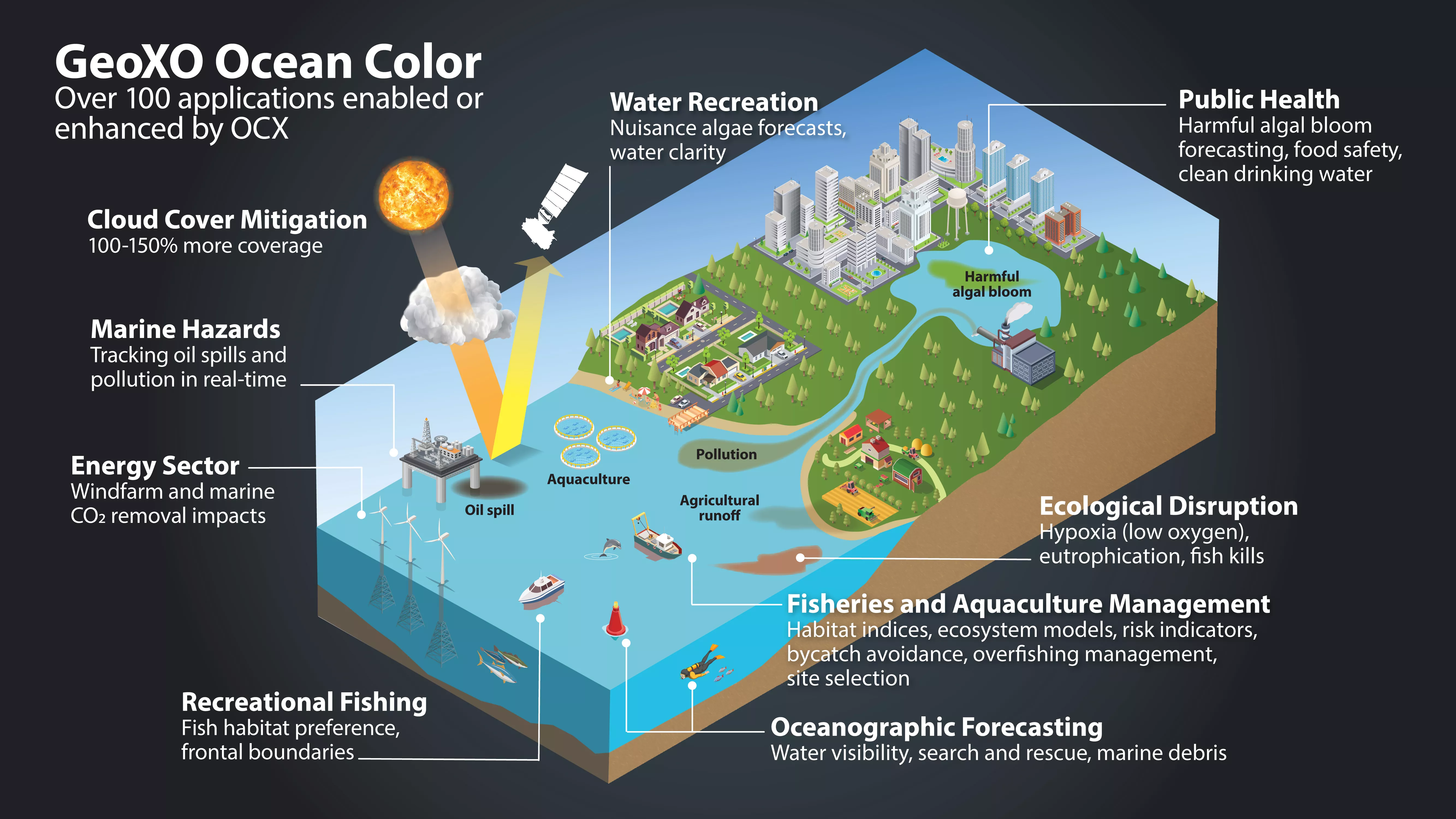
Having ocean color instruments onboard NOAA’s geostationary satellites will be a game changer. Polar-orbiting satellites only pass over certain areas once or twice a day, and might miss things like harmful algal blooms if they're hidden under clouds. However, geostationary satellites orbit at the same speed that the planet rotates, remaining over the same area. This allows them to constantly monitor that specific area, and watch for when the clouds move, revealing what is underneath.
OCX is a hyperspectral instrument that will analyze a wide spectrum of light from ultraviolet to near-infrared. This information will be critical for distinguishing types of phytoplankton to support aquaculture activities and for tracking algal blooms in coastal waters, which are more complex due to dissolved pigments and sediments.
OCX will also provide higher resolution data than what is currently available. High-resolution ocean color imagery will improve observations of water clarity and chlorophyll concentration as well as provide better detection of harmful algal blooms and coastal pollutants. Finer resolution will also allow scientists to better monitor water quality within smaller bodies of water and along the coast where urbanization and high nutrient runoff have an increasingly negative impact on the livelihoods of local communities.
Frequent, high-resolution ocean color imagery will help NOAA provide more accurate and timely forecasts and scientific guidance to federal, state, and local agencies. OCX observations will support ecological forecasters, marine resource managers, fisheries, health departments,water treatment managers, and the commerce, recreation, and tourism industries. NOAA expects that GeoXO will begin operating in the early 2030s, taking over for the GOES-R Series as it nears the end of its operational lifetime.


