Cookies.
This website uses cookies, which are small text files that the website puts on your device to facilitate operation. Cookies help us provide a better service to you. They are used to track general user traffic information and to help the website function properly.
Features
Nearby features appear when you click the map.
Declutter tracks on map.
Place Search
Video
X
Pub: by
Mweelrea Area , E: Ben Gorm Mountains Subarea
Feature count in area: 12, all in Mayo, OSI/LPS Maps: 37, EW-CON, MSW
Highest Place: Mweelrea 814m

Starting Places (31) in area Mweelrea:
Aasleagh Waterfall CP, Ben Creggan N, Bundorragha Estuary Cross, Bunleemshough River Source, Carraig Bar, Delphi Resort, Dernasliggaun, Doo Lough N, Doo Lough SE, Fee Lough SW, Foher, Glencraff Road End, Glencullin Lough CP, Glendavock, Glenummera River, Illaunroe North, Illaunroe South, Killary Boat Tour Pier W, Leenane, Leenane Hotel, unuseableLeenane R336, Lough Fee East, Muck Lough NW, Nambrackkeagh Lough, Owenduff River, Owengar Bridge, Owenwee River, Sean Scoil an Talaimh Bháin, Silver Strand Road, Tawnydoogan Forest Central, Tawnydoogan Forest North

Summits & other features in area Mweelrea:
E: Ben Gorm Mountains: Ben Creggan 693m, Ben Creggan South Top 687m, Ben Gorm 700m
W: Mweelrea: Ben Bury 795m, Ben Lugmore 803m, Ben Lugmore East Top 790m, Ben Lugmore West Top 790m, Corrymailley Hill 286m, Mweelrea 814m, Mweelrea SE Spur 495m, Tawnydoogan 312m, Teevnabinnia 379m

Note: this list of places may include island features such as summits, but not islands as such.
Rating graphic.
Ben Gorm, 700m Mountain An Bhinn Ghorm A name in Irish,
Place Rating ..
(Ir. An Bhinn Ghorm [MNIMA*], 'the blue peak'), Binn Ghorm, Mayo County in Connacht province, in Arderin, Vandeleur-Lynam, Irish Best Hundred, Irish Highest Hundred Lists, Ben Gorm is the 115th highest place in Ireland. Ben Gorm is the most easterly summit and also the second most southerly in the Mweelrea area.
Grid Reference L86227 65242, OS 1:50k mapsheet 37
Place visited by: 356 members, recently by: DeirdreM, keith.dillon, rhw, MeabhTiernan, taramatthews, srr45, PiotrR, Carolineswalsh, abeach, Barrington1978, Timmy.Mullen, Krzysztof_K, Kaszmirek78, glencree, miriam
I visited this place: NO (You need to be a logged-in member for this.)
Longitude: -9.721075, Latitude: 53.624709, Easting: 86227, Northing: 265242, Prominence: 670m,  Isolation: 1km
ITM: 486152 765254
Bedrock type: Sandstone & conglomerate, ignimbrite, (Mweelrea Formation)
Notes on name: An Bhinn Ghorm is a mountain name which occurs 3 times in Co. Mayo. Ir. gorm is usually translated 'blue', but Breandán S. Mac Aodha suggests that 'iron-grey' is closer to the true meaning in such mountain names (MNIMA, 149). Walks: for a route taking in Ben Gorm and Ben Creggan, see Whilde & Simms, New Irish Walk Guide - West and North, 60-61.
  Short or GPS IDs, 6 char: BnGrm, 10 char: Ben Gorm

Linkback: https://mountainviews.ie/summit/110/
Gallery for Ben Gorm (An Bhinn Ghorm) and surrounds
Summary for Ben Gorm (An Bhinn Ghorm): Flattish Summit - high point of an exciting and rugged range.
Summary created by markmjcampion, Onzy 2021-03-27 17:21:32
            MountainViews.ie picture about Ben Gorm (<em>An Bhinn Ghorm</em>)
Picture: Ben Gorm from the south east.
Ben Gorm is the most southerly peak in the compact range of hills that form the Ben Gorm group. There are fine coums as well as long raking spurs that extend to the E. It lies close to Killary Harbour and the Mweelrea - besides these, there's lots to see from the summit incl. Devilsmother, the Sheffreys and Clare Island. The ridges are narrow in places with steep ground in abuncance along with a possible feeling of exposure to be experienced.

SE. Park at Aasleagh Falls ( Aasl Falls (L89342 64412)) where there is ample parking. Head up between a double row of fences until meeting the ridge line of the most S spur and head W keeping the coum on your right. There's wet ground lower down but it's better going once you attain the spur. Allow 2 hrs.+
If trying to complete an entire circuit note that it will involve a long trek through bog to the E of the main ridge as well as potentially difficult crossings of the Glendavock and Lugayeran rivers.

NE. Another starting point is at the E end of the N spur, around Gl'Vck (L88803 67234), heading S onto the spur, then W to Ben Creggan, over its S top and onto BG - about 2.5 hrs.
Parking further E at forest entrance you can head through the forest to approx. A (L93099 67094) and walk BG's long eastern spur to the summit. Allow 2.5 hrs+

W. A third starting point is at Delphi Lodge ( Delphi (L84006 65000)) heading straight and v steeply for the summit - approx. 1 hr.

Notable tracks incl. track/3699 , track/3073 [car split] and the lengthy track/2735.
Linkback: mountainviews.ie/summit/110/comment/4870/
Member Comments for Ben Gorm (An Bhinn Ghorm)
Comment create / edit display placeholder

            MountainViews.ie picture about Ben Gorm (<em>An Bhinn Ghorm</em>)
Picture: View of Killary Harbour from the slopes of Ben Gorm as the sun sets
mcrtchly on Ben Gorm
by mcrtchly 25 Jun 2009
A great evening climb of Ben Gorm, still on the summit at 9pm and got down as it was getting dark. Access from the Ashleagh Falls car park was a little difficult. The start of the route described by Lynam is along the track besides the falls - this is no longer accessible as the gate was locked and the road marked Private. The alternative is to take the route between the two lines of fences running up the hillside from the car park. Note that the ground is wet in places and you should stick mainly close to the left fence. A gate at the end of the line of fences leads on to the hillside. Beware of long grass as annoying tussocks which make the progress very slow until the ridge line is reached. The climb along the ridge is steep in places and you can scramble on the rocks if you wish. Found the 'real' summit using GPS co-ordinates given by rmilne. Cloudless evening with great views of Killary, Twelve Pins. and Clare Island. A highly recommended climb. Linkback: mountainviews.ie/summit/110/comment/3885/
Read Less
Read More

            MountainViews.ie picture about Ben Gorm (<em>An Bhinn Ghorm</em>)
Picture: long ridge from Tawnyard Lough
gerrym on Ben Gorm
by gerrym 30 Mar 2008
I have tackled Ben Gorm from the south with the relatively short and easy climb from Ashleagh falls. For this walk I approached from the north, taking in the long central ridge rising near Tawnyard Lough. The start of the walk is reached through the beautiful Glenummera valley which has the Sheeffry Hills towering above its northern side and the Ben Gorm mountains on it southern side. Park at entrance to forest above Tawnyard Lough (B (L914 678)) where there is parking for several cars and an informative information board on the area. Follow the track down into the forest, take turn to right and follow roughly hewn track as crosses bridge and river flowing into Lough. Continue until leave the forest and take the open ground to the right which leads onto the 6 km ridge to the summit of Ben Gorm. A fence leads for quite a distance and if the magnificent scenery isn't doing the trick a quick hold will provide a jolt to the senses. The ground is quite wet until reach point 356m (C (L897 662)), from here there is a slight descent before firmer rockier ground starts. The ridge begins to narrow and there are big drops into the river valley to the north and the corrie to the south containing little Lugaharry Lough. There are good views north to the Sheeffrys (shrouded in mist) and to the two tops of Ben Creggan, south the Devilsmother rises dramatically from the Eriff river valley, with the Bens and Mamturks in the distance. The ridge gives a great feeling as it narrows and becomes rockier. Numerous stops were taken to look back along the length of the ridge and to the surrounding high and low ground - breathtaking! I stuck to the northern side as curved around passing a cairn on its way to the summit cairn itself (a walk of nearly three hours and no one else to bump into). Mist was floating around the top so I only had glimpses of the views to the Twelve Bens across Killary Harbour. From the top it is a drop down NW passing another small cairn on the drop to the col with Ben Creggan S Top. (see for next part of walk). Linkback: mountainviews.ie/summit/110/comment/1285/
Read Less
Read More

            MountainViews.ie picture about Ben Gorm (<em>An Bhinn Ghorm</em>)
Picture: Middle descent ridge
A super day out
by david bourke 28 Sep 2011
Climbed Ben Gorm and Ben Creggan on the 25th September 2011. Commenced at Killary and made ascent to the ridge via the double line of fences from the car park. Rather wet at start but once on the ridge it was a gentle pull up on to the summit on good terrain. Continued on to Ben Creggan. Got hit by a hail storm on the initial climb to the spot height 687 but by the time the main summit was reached the sun shone and with strong winds the wet gear soon dried out. Returned on to the summit cairn of Ben Gorm and descended the central ridge shown in picture. It was then a short descent off this ridge to cross the Lugayeran River and final return down over the long tussocky grass to the car park near the Ashely Falls. Started at 11am and finished at 5pm. It is a most rewarding climb and the views of Mweelrea, The Sheefrys,Devilsmothers, Maumstrasna are unrivaled. Ashley Briege Car park I Aasl Falls (L893 644) Ben Gorm Cairn ID (L862 652). Ben Creggan Spot Height 687 IE (L858 660). Ben Creggan Summit Cairn IF (L857 666). Central Spur exit point IG (L883 657). Lugayeran River Crossing IH (L886 650) Linkback: mountainviews.ie/summit/110/comment/6534/
Read Less
Read More

            MountainViews.ie picture about Ben Gorm (<em>An Bhinn Ghorm</em>)
Approaching from the south east
by ColinCallanan 20 Jun 2015
Incredible views all the way as you approach from the south-east. I used the track from Onzy and found it very helpful. Linkback: mountainviews.ie/summit/110/comment/18145/
Read Less
Read More

The sting in the tail...........
by millsd1 11 Aug 2013
Parked at entrance to forest above Tawnyard Lough LB (L914 678) and proceeded westwards along the road to Gl'Vck (L888 673)
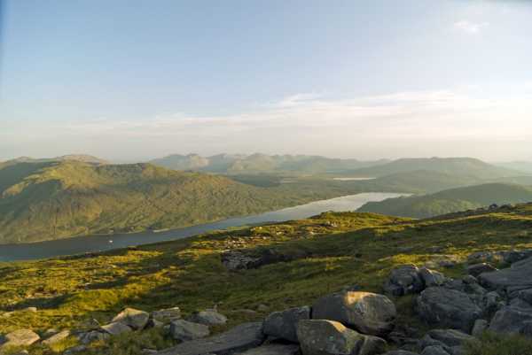
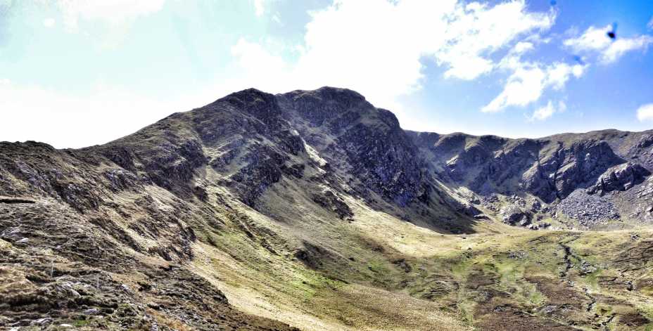
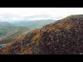
. Then turned south to access (through a few hundred metres rough clear felled forest) the rocky northern spur leading to summit of Ben Creggan. We started the walk in rain and poor visibility but conditions had improved dramatically by the time we summited Creggan, it was well worth the effort.

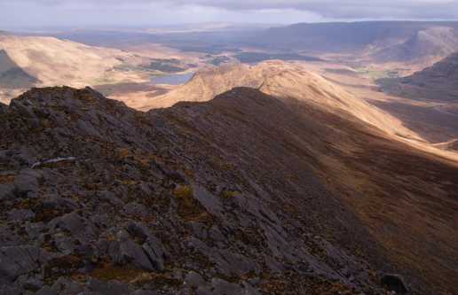
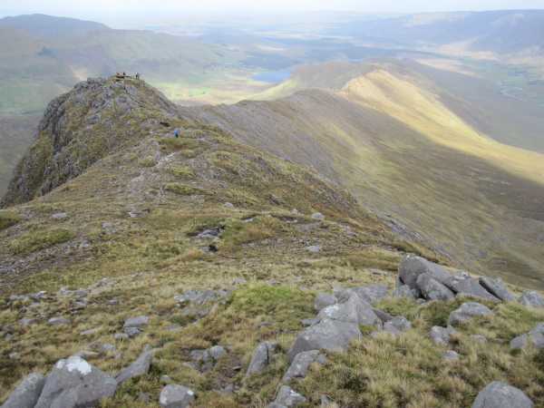
From there proceeded to Ben Creggan S. Top and Ben Gorm before descending via the 6km long central spur. As other members have commented, there are great views of all the surrounding ranges and I'm not going to try and improve on their descriptions. The purpose of this comment is to high-light a couple of potential hazards at the lower (eastern) end of the central spur.

Our intention was to descend the central spur and link up with the Western Way to return to the car. The plan was to leave the spur at about J (L915 666) and descend to the southern most of the two parallel east/west forest tracks shown on the map south of Derrintin Lough . The tracks could be clearly seen from this vantage point and while they looked a bit overgrown, they appeared viable. They aren't! Closer inspection revealed impenetrable rough terrain.
The second hazard is the 5 strand fence bordering the southern edge of the forest from about K (L917 666) to L (L931 671). It's electrified and packs quite a kick. Ensure you hand-rail this fence metaphorically rather than literally!

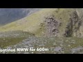
The sensible route is to stick to the crown of the spur all the way to / from L (L931 671). You'll still have to cross the fence but there is an insulated section here to facilitate this.
Also, watch out for a single live supply wire at waist height joining the fence from the south at about M (L928 668). You can duck under this one though.

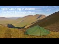
Notwithstanding the difficulties encountered near the end, this is a truly memorable ridge walk and one that I will repeat. Linkback: mountainviews.ie/summit/110/comment/15063/
Read Less
Read More
EDIT Point of Interest
text
Videos


Recent Contributions
x
Conditions and Info
Use of MountainViews is governed by conditions and a privacy policy.
Read general information about the site.
Opinions in material here are not necessarily endorsed by MountainViews.
Hillwalking is a risk sport. Information in comments, walks, shared GPS tracks or about starting places may not be accurate for example as regards safety or access permission. You are responsible for your safety and your permission to walk.
See the credits and list definitions.

OSi logo
OSNI/LPS logo
Open Street Map
(Various variations used.)
British summit data courtesy:
Database of British & Irish Hills