News

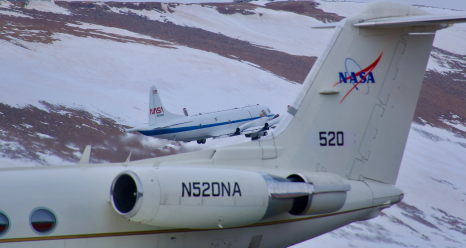
Two NASA aircraft are taking coordinated measurements of clouds, aerosols and sea ice in the Arctic this summer as part of the ARCSIX field campaign. In this image from Thursday, May 30, NASA’s P-3 aircraft takes off from Pituffik Space Base in northwest Greenland behind the agency’s Gulfstream III aircraft. Credit: NASA/Dan Chirica

NASA Mission Flies Over Arctic to Study Sea Ice Melt Causes

It’s not just rising air and water temperatures influencing the decades-long decline of Arctic sea ice. Clouds, aerosols, even the bumps and dips on...

Read More
The NASA DC-8 aircraft lifts off on a flight from U.S. Air Force Plant 42 in Palmdale, California, at sunset. The DC-8 is based at NASA’s Armstrong Flight Research Center Building 703, which is located on Plant 42. NASA/Carla Thomas

NASA Teammates Recall Favorite Memories Aboard Flying Laboratory

After flying more than three decades and 158 science campaigns, just one flight remains. NASA’s DC-8 Airborne Science Laboratory will make its final...

Read More
Kirsten Boogaard, Deputy Project Manager for the DC-8 aircraft, leads and manages project planning, integration and resources for airborne science missions since 2020. NASA/Ken Ulbrich

Meet NASA Women Behind World’s Largest Flying Laboratory

NASA’s DC-8 aircraft – the world’s largest flying science laboratory – began its science missions in 1987 and since then, has flown in service...

Read More
HARP2, short for Hyper Angular Rainbow Polarimeter 2, undergoes calibration testing prior to launch aboard PACE. NASA/Denny Henry

NASA’s ORCA, AirHARP Projects Paved Way for PACE to Reach Space

It took the Plankton, Aerosol, Cloud, ocean Ecosystem (PACE) mission just 13 minutes to reach low-Earth orbit from Cape Canaveral Space Force Station ...

Read More
The Mackenzie River in Canada plays a major role in Arctic climate as warmer fresh water mixes with cold seawater.  This image was taken by the Operational Land Imager on the Landsat 8 satellite on July 18, 2017.

NASA Selects New Aircraft-Driven Studies of Earth and Climate...

NASA has selected six new airborne missions that include domestic and international studies of fire-induced clouds, Arctic coastal change, air quality...

Read more

Hazy Skies in a Growing City

Chiang Mai, the largest city in northern Thailand, is famed for having hundreds of Buddhist temples, some of which date to the city’s founding in th...

Read more

Grappling with Thailand’s Seasonal Haze

Each year in January and February, satellites begin to detect waves of smoke and fire in Southeast Asia, particularly in highland forests in Cambodia,...

Read more

About the Airborne Science Program


The Airborne Science Program within the Earth Science Division is responsible for providing aircraft systems that further science and advance the use of satellite data. The primary objectives of this program are to:

  • Satellite Calibration and Validation
    Provide platforms to enable essential calibration measurements for the Earth observing satellites, and the validation of data retrieval algorithms.
  • Support New Sensor Development
    Provide sub-orbital flight opportunities to test and refine new instrument technologies/algorithms, and reduce risk prior to committing sensors for launch into space.
  • Process Studies
    Obtain high-resolution temporal and spatial measurements of complex local processes, which can be coupled to global satellite observations for a better understanding of the complete Earth system.
  • Develop the Next-Generation of Scientists and Engineers
    Foster the development of our future workforce with the hands-on involvement of graduate students, and young scientists/engineers in all aspects of ongoing Earth science investigations.

To meet these observing objectives ASP maintains and operates a suite of sustained, ongoing platforms and sensors on which investigators can rely from year to year. From these known capabilities the Science Mission Directorate can develop observing strategies. However, an ongoing capability will be resource-constrained and eventually technology-constrained, so that not all observing requirements will be met with the limited core capability. Therefore the program facilitates access to other platforms or sensors on a funds-available, as-needed basis, to accommodate unique and/or occasional requirements. The Program also looks for new or evolving technologies to demonstrate their applicability for Earth science. Depending on the success of the demonstrations and the observing needs, the core capability is expected to evolve and change over time. The speed and extent of change will be balanced against the need for established, known capabilities for long-term planning.